Before the United States was a concept, before the British staked their claims, the French crown looked at the map of North America and saw a giant blank space broken only by rivers. The European entry into what we now call Wisconsin was not a conquest of armies. It was an entry of isolated groups: lone explorers, fiercely independent traders, and Jesuit priests who walked straight into an established Indigenous world.
They did not conquer the land; they adapted to it, used it, and forever altered its trajectory. Understanding this history explains many things about our state: how many places got their names, the significance rivers have always had here, and why Wisconsin was and remains one of America’s most Catholic states.
The Nicolet Miscalculation
In 1634, Samuel de Champlain, the Governor of New France, sent Jean Nicolet west from Quebec. Nicolet’s mission was twofold: negotiate peace between the Huron and western tribes to secure the fur trade, and find the fabled Northwest Passage to Asia.

Nicolet was so convinced he was going to hit China that he packed a fancy silk robe embroidered with colorful birds and flowers. When his birchbark canoe pulled ashore at Red Banks, just north of modern Green Bay, he stepped out onto the mud wearing this elaborate Chinese court gown and firing two horse pistols into the air to impress the locals.
Instead of Chinese, Nicolet met the Ho-Chunk people, whom the French recorded as the Puants. The Ho-Chunk were hospitable but reportedly unimpressed by the Asian attire. While Nicolet did not find China, nor the Pacific Ocean, he found something the French valued almost as much: an incredibly dense population of beaver and a water highway leading into the interior of the continent.
The Highway of Empire
The French footprint in Wisconsin survived because of geography. The state sits on a unique continental divide. The Fox River flows north into Green Bay and the Great Lakes; the Wisconsin River flows south into the Mississippi. They meet at a narrow, muddy strip of land just 1.5 miles wide in modern Columbia County: the Portage.
By carrying canoes across this short patch of wet prairie, a traveler could paddle from the Atlantic Ocean all the way to the Gulf of Mexico. This became the literal axis of the French empire in the West.
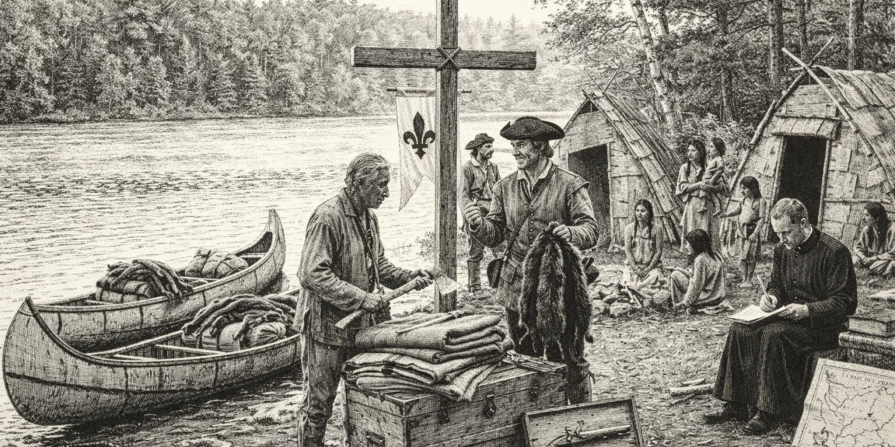
The Three Pillars: Traders, Explorers, and Priests
The French map stayed together because of an uneasy triad: corporate hustlers, royal mapmakers, and zealots who often despised each other but could not survive alone. The raw economic engine of the whole enterprise was the fur trade, driven by a European fashion obsession with felt hats made from beaver under-fur. Since Europe had hunted its own beavers to near-extinction, Wisconsin became the new global supply chain.
The frontline laborers of this supply chain were the voyageurs. These men paddled 14 hours a day in birchbark canoes, surviving on a punishing diet of dried peas, lard, and cornmeal. They were famous for singing rhythmic rowing songs to keep time and for their sheer physical ability to carry multiple 90-pound packs across rugged portages.
Sometimes the traders moved faster than the crown could track them. In 1659, Pierre-Esprit Radisson and Médard Chouart des Groseilliers traveled into northern Wisconsin without the permission of the French governor. They wintered near Chequamegon Bay on Lake Superior, trading with the Ojibwe and Dakota. When they returned to Montreal with a massive haul of premium furs, the governor confiscated their pelts for trading without a license. Insulted, the duo went straight to the British crown and helped found the Hudson’s Bay Company, which became New France’s greatest corporate rival.
Close behind the rogue traders came the formal explorers, mapping the interior to claim it for Louis XIV. In 1673, Father Jacques Marquette and Louis Joliet set out from St. Ignace to find where the great western river led. Guided by Indigenous maps, they paddled up the Fox River, crossed the Portage, and entered the Wisconsin River. On June 17, 1673, they drifted out onto the Mississippi River near Prairie du Chien, opening the American interior to European mapping. Later, diplomats like Nicolas Perrot built Fort St. Nicolas at Prairie du Chien in 1685 and established trade posts along the Mississippi. Perrot understood Indigenous diplomacy better than almost any other Frenchman, successfully managing volatile alliances between the Miami, Outagamie, and Sioux.
Then there were the priests, the Black Robes, operating under a completely different directive: saving souls. The Jesuit missionaries established missions at key geographic chokepoints, such as Father Claude Allouez founding the Mission of La Pointe on Lake Superior in 1665 and the Mission of St. François Xavier at De Pere in 1671. Unlike later American or British missionaries, the Jesuits did not try to Europeanize the Native populations immediately. They learned languages like Algonquin and Menominee, lived in native villages, and used indigenous concepts to explain Christian theology. Their detailed reports, sent back to France as the Jesuit Relations, remain some of the best historical accounts of 17th-century Wisconsin life.
The Middle Ground and Its End
Unlike the British, who brought families to clear land and build permanent farming towns, the French sent mostly single men. To survive, French traders married into Indigenous families. This created a hybrid society known as the Middle Ground, a culture of mutual accommodation where neither side could entirely dominate the other. Out of these unions emerged the Métis culture, which combined French language and Catholicism with Indigenous hunting, trading, and diplomatic traditions. Green Bay and Prairie du Chien grew out of these specific fur-trade communities.
The French system was lucrative but fragile. It depended entirely on keeping the peace along the waterways. When the demand for furs caused resource depletion and weaponized intertribal conflicts, the system fractured. By the time the British defeated France in the French and Indian War in 1763, the French political regime vanished from Wisconsin, leaving behind a map covered in French names like Eau Claire, Fond du Lac, and Prairie du Chien, alongside a deeply embedded trade network that would dictate territorial politics for another half-century.
Previously at Dairyland Sentinel
For additional information
The French Régime in Wisconsin and the Northwest
The Middle Ground: Indians, Empires, and Republics in the Great Lakes Region, 1650–1815
Joliet and Marquette, 1920 Milwaukee Journal


